Gypsum domes and diapirs: common features
The Upper Permian Zechstein deposits were deposited in a nearly closed inland sea that was structured by palaeohighs into subbasins. The main basin extended from England to Poland (Peryt et al., 2010a). The Zechstein sequence, up to a few kilometres thick, consists of classical evaporite cycles that form the frame work of the stratigraphy (Richter-Bernburg, 1955; Table 1). The Zechstein cycles start with marine carbonates, followed by sulphates, rock salt and then potassium salts. In Germany, there are six cycles starting with marine mudstones or carbonates and ending with rock salt or potassium salts; the seventh cycle, which corresponds to the Fulda Formation, consists only of terrestrial strata.
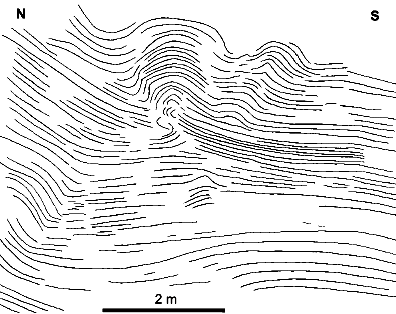
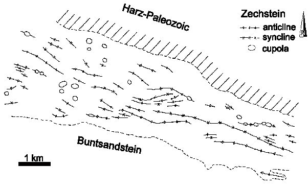
During mining of potassium and rock salt in Sachsen-Anhalt near Stassfurt in the second part of the 19th century, geologists observed and described irregular thicknesses of the Leine Anhydrite (A3). Everding (1907) indicated that in this area the thickness of A3 varies between 40 and 90 m. A detailed description of this phenomenon was given by Fulda (1929). He termed the elevations ìanhydrite cliffsî and differentiated between small features, several metres high, and large ones, up to 50 m high. Hemmann (1968, 1972) described the domes in detail and summarized the various theories of their genesis. His observations indicated that the A3 domes in the Stassfurt area are up to 50 m high, 15 to 120 m across and can be traced horizontally over distances of several hundred metres (Fig. 1). Very often their Upper part is expanded and has a pear-like shape with steep flanks. Thin, but long protrusions of anhydrite extend along bedding planes into the neighbouring rock salt. Around these domes the thickness of A3 is reduced to 16 m or less (Fig. 1). T a b l e 1 Zechstein strata around the Harz Mts.
Symbols after Richter-Bernburg (1955): T ñ claystone, Ca ñ carbonate, A ñ anhydrite, Na ñ rock salt; basin data refer to the Subhercynian Basin north of the Harz Mts. and palaeohigh data to the Eichsfeld-Altmark High; data mainly from Hemmann (1972) and Paul (1993) Hemmann (1972) noticed that the anhydrite domes ñ especially near their tops ñ contain numerous salt crystals for up to a third of their total volume, and in turn the rock salt above the anhydrite domes contains more anhydrite crystals than in areas where no domes are present. He also remarked that only the Upper part of A3 is involved in the formation of the dome (Fig. 2). Schachl (1991) made similar observations in a mine in the Allertal district.
Modified after Hemmann (1972); for abbreviations and thicknesses
1 ñ Stassfurt, 2 ñ Bernburg, 3 ñ Schönebeck, 4 ñ Upper Aller River valley, According to Jung et al. (1969) and Hemmann (1972), the A3 profile shows compositional and textural differences which are used for its detailed stratigraphic subdivision (Table 2). In the Stassfurt area, the lower most subunit (dark grey A3α, cf. Fig. 1) is only up to three metres thick, has a high carbonate content and was deposited in a sabkha environment. The development of other subunits of A3 varies between chicken-wire and well-bedded anhydrite. But, these horizons are not consistent in the Zechstein basin and may change from region to region (but see Reimann and Richter, 1991). The uplift of the anhydrite is terminated by a series of anhydrite (am1) layers (Fig. 1). Near the domes there are often large anhydrite blocks or clasts (Fig. 1). The importance of this observation is discussed below in the chapter ìInterpretation and Discussionî. T a b l e 2 Stratigraphy, thickness and characteristics
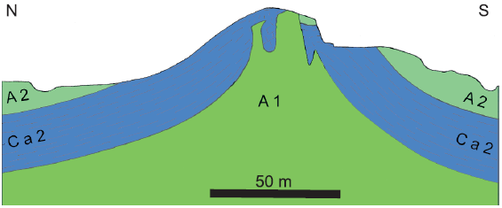
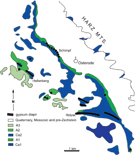
Another type of Gypsum doming and diapirism from central Germany, at the south-west margin of the Harz Mts., was described by Paul (1987) and Williams-Stroud and Paul (1997). Here, the Gypsum is not overlain by rock salt, but by carbonates: the Stassfurt Carbonate (Table 1). A broad belt of Zechstein strata crops out south of the Variscan Harz Mts. A more or less NEñSW striking palaeohigh, the Eichsfeld-Altmark High (EAH), crosses the Harz Mts. (Figs. 2 and 3). After the Late Cretaceous, the area was uplifted and the Mesozoic cover was eroded. |
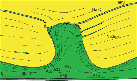
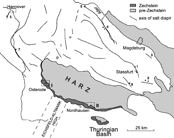
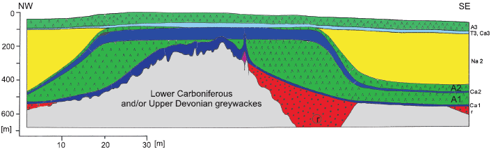
Fig. 3. Schematic cross-section of the Eichsfeld-Altmark High
r ñ Rotliegend (Lower Permian), Ca1 ñ Werra Carbonate, A1 ñ Werra Anhydrite,
Ca2 ñ Stassfurt Carbonate, A2 ñ Stassfurt Anhydrite, Na2 ñ Stassfurt Salt,
T3 ñ Leine Clay, Ca3 ñ Leine Carbonate, A3 ñ Leine Anhydrite
Borchert and Baier (1953) demonstrated that in the Zechstein basin all thick marine sulphate horizons were originally precipitated as Gypsum. Kosmahl (1969) confirmed this for A3 as he found pseudomorphs of swallow-tail crystals which are typical of Gypsum origin.
West of Osterode, there are several Gypsum quarries with a combined length of several kilometres along the escarpment of the Söse River. These quarries allow for a two-dimensional, often also three-dimensional, view of the Upper A1 and its contact with the overlying Ca2 (Fig. 5). The boundary of A1 with Ca2 is wavy. Formerly it was supposed that this wavy surface is the result of recent partial leaching and underground erosion of the Gypsum, or that it was overlooked (cf. Herrmann and Richter-Bernburg, 1955; Herrmann, 1957).
The abbreviations of stratigraphic units are explained in Figure 3 Ten metres below the diapirs the Gypsum is horizontally bedded, bedding planes show a larger detachment and some sections show flaser structure. There are selenite horizons in the lower part of A1 whereas no selenite has been found within the diapirs (Fig. 7).
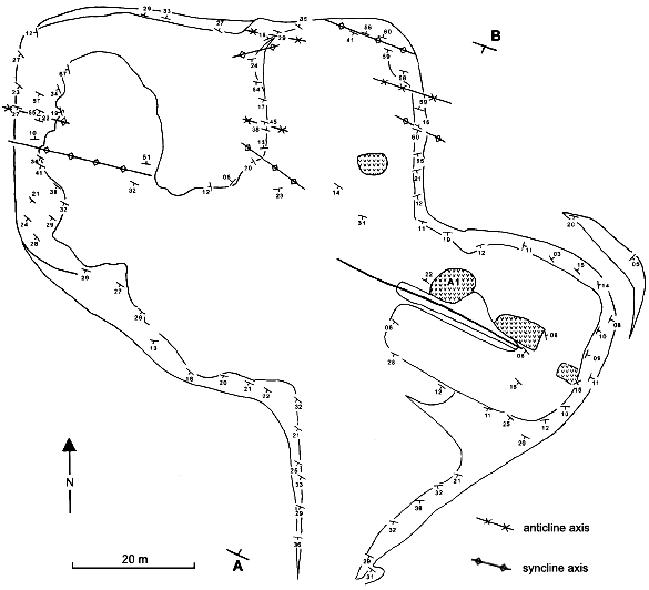
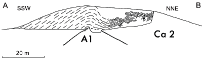
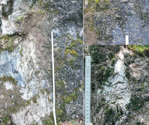
The relation of the overlying Ca2 to the rising Gypsum masses can best be seen in a disused quarry at Hellenberg, 2 km away from Osterode (Fig. 8) where an elongate ridge consisting of quarried Ca2 rocks is exposed. The underlying A1 is also exposed in some places. Ca2 consists of well-bedded dark grey dolomudstones and dolowackestones; the beds are a few centimetres to half a metre thick. Ca2 is heavily deformed by slumping, sliding, folding and faulting (Figs. 8ñ11). The main fold axis is marked by the highest position of the underlying Gypsum (Fig. 9). It can be traced throughout the quarry, and strikes about 130° (Fig. 10). Slump directions are perpendicular to this direction. Bedding planes of Ca2 dip at 20ñ40° at right angles to the fold axis (Figs. 8 and 10). The northern part of the quarry is dominated by folding (Fig. 11A). At the fold axes, dolomite beds are brecciated. Sliding is the prevailing process at the western and southern parts of the quarry. Carbonate blocks have slid downslope. Slickensides are uneven, but always perpendicular to the main axis (Fig. 11B). There is no secondary calcite that would indicate deformation in a solid state at the slickensides. The temporal succession of events can be reconstructed in some cases (Fig. 11B); slickensiding took place after sliding. All this deformation took place in a semi-lithified state of the Ca2 carbonate.
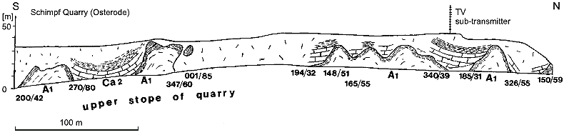
The Rötzel is an elongate ridge south-west of Osterode (Figs. 4 and 12ñ14). The ridge is about 200 m wide at the base, but only a few metres wide at the top. It is about 30 m high and can be traced morphologically over a distance of two kilometres. |
AñB ñ position of the section; the scale is for horizontal and vertical directions;
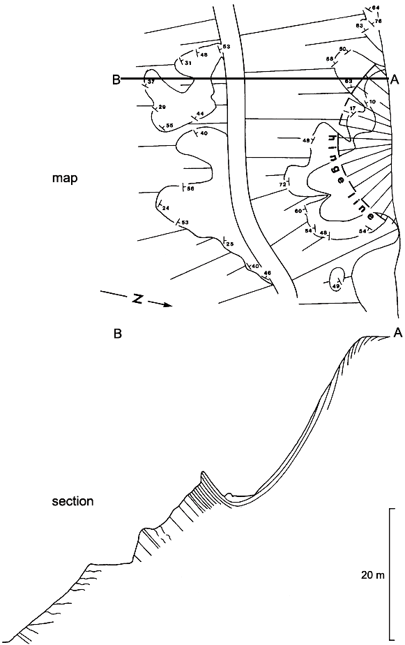
South of the Harz Mts. at Nordhausen (Fig. 2), the cover of Quaternary deposits above the Zechstein is thinner than in the other areas around the Harz Mts. Paul et al. (1998) mapped an area of about 40 km² in the scale of 1:10,000, especially focusing on the sulphate horizons of the Zechstein (Fig. 15). This mapping yielded detailed information about the deformation of the sulphate. It was found that all over the mapped area, A1 was completely folded as in a fold belt. This was neither expected nor observed before, as in non-Alpine Central Europe the post-Variscan strata are a flat-lying layer-cake. Narrow and acuate anticlines are in contrast to broad and gentle synclines.
At the eastern border of the Rheinisches Schiefergebirge near Adorf, Gypsum of the Werra Anhydrite (A1) has been extracted since late medieval times from an underground pit which is now closed. Due to its location near the palaeocoast-line of the Zechstein sea, a few clay layers are intercalated with the Gypsum; typically, there are three Gypsum beds. The total thickness of A1 is about 40 m (Kulick, 1987). Finkenwirth (1982) described, from the lower most Gypsum bed, round Gypsum domes 10ñ20 m in diameter and 10 m in height. Slopes of the domes are up to 45° steep. The claybeds covering the Gypsum are also upwarped and deformed. There is no information about the form of the domes and their preferential direction.
Gypsum doming and diapirism are quite common features in the Zechstein around the Harz Mts. Former interpretations of these features are quite different: Fulda (1929) explained the A3 cliffs by a primary rise of precipitation due to an increased brine flow in convection cells; Weber (1931) and Richter (1934) thought that the A3 domes were included in the uplift of the rock salt ñ most workers agreed with this opinion and drew in their diagrams and drafts faults between Gypsum and rock salt (cf. Seidl, 1914; Fleischer, 1960). This interpretation was also adopted in text-books at the time (Lotze, 1938; Borchert, 1959). Richter-Bernburg (1985) described these ìcliffsî as problematic structures of partly tectonic origin and partly synsedimentary precipitations. Langbein (1987) cited Hemmann (1972) and concluded that the cliffs ìremain especially problematicî.
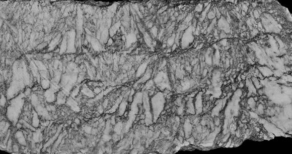
Width of the photo ñ 20 cm (photo T. Paul) In contrast to these opinions, Hemmann (1972) realized that Gypsum diapirism is in dependent of salt diapirism. He also noticed that only the Upper parts of A3 were included in the movement of the sulphate. From the high amount of rock salt crystals within the anhydrite domes and the high percent age of Gypsum within the rock salt above the domes, he concluded that the sulphate at the time of uplift was still Gypsum, highly mobile and containing a large volume of water. Although Hemmann (1972) and Schachl (1991) did not use the term diapir ñ mainly for linguistic reasons, they used the German word ìKlippeî meaning ìcliffî ñ it is clear that large anhydrite clasts of up to five metres across occurring within the rock salt adjacent to the domes prove that the surface of the sulphate penetrated the salt roof and parts of the sulphate broke off and slid away from the diapir (Fig. 1). These processes occurred before the Gypsum was converted to anhydrite. Anhydrite is brittle, not ductile, and not mobile like rock salt.
Fig. 8. Sketch-map of Hellenberg Quarry, west of Osterode Direction and dip of Staßfurt Carbonate (Ca2) beds; A1 ñ Werra Anhydrite;
Fig. 9. Schematic cross-section of the Hellenberg Quarry Thin lines indicate bedding planes; the thick line represents
Fig. 10. Slump structures at the Hellenberg Quarry The drawing-lines are bedding planes of Ca2; My observations confirm Hemmannís (1972) description but the interpretation differs in several aspects. Hemmann (1972) thought that Gypsum diapirism is triggered by water liberated due to the conversion of Gypsum to anhydrite. After Borchert and Baier (1953) it was thought that about 0.5 m³ of water is discharged from 1 m³ of Gypsum. The detailed conditions of the conversion are still under discussion (Braitsch, 1962; Hardie, 1967; Langbein, 1968, 1987; Langbein et al., 1982; Warren, 1999). The depth at which conversion takes place depends on temperature, geothermal gradient, lithostatic pressure and the types and concentrations of pore brines. Most likely, these processes took place at a depth of about one hundred metres (Marsal, 1952); for Zechstein, Langbein (1987) assumed that the minimum depth was 100 m.
In the Nordhausen area there occur round cupolas, though elongate ridges or anticlines prevail (Fig. 15). In the Osterode area the A1 diapirs strike between 90 and 120°; in the Nordhausen area they are strictly about 120° (Fig. 15). The A3 diapirs north of the Harz Mts. strike in various directions: Hemmann (1972) reported strikes for the Bernburg mining district being mainly 110ñ150°, but also 20ñ50°; in the Stassfurt district they are about 50°; in the Aller River valley about 140 and 50°. It seems that the A3 diapirs strike parallel and normal to the direction of the salt diapirs, but these observations were made on Gypsum diapirs located on the slopes of large salt diapirs, and therefore their orientation may have been changed.
Fig. 11. Hellenberg Quarry A ñ folds in Ca2 at the Hellenberg Quarry (breadth ñ 2 m);
A1 ñ Werra Anhydrite, Ca2 ñ Stassfurt Carbonate,
Fig. 13. Sketch-drawing of the central part of Figure 12 Red quadrangle shows position of Figure 14
Fig. 14. Rötzel diapir A ñ vertical contact of white Gypsum (A1) on the left side and brecciated black and grey carbonate (Ca2) at the right side; the boundary between both rocks is jagged; grey spots within the Gypsum consist of dolomite; the dolomite is completely brecciated (length of the rule ñ 1 m); B ñ angular carbonate dolomite clasts with out matrix (length of rule ñ 5 cm); C ñ Gypsum within the dolomite (Ca2), most likely, the fill of a cavity In the case of A1 in Osterode and Nordhausen areas, the orientation of Gypsum ridges is exactly parallel to the direction of Hercynian faults (like the Northern Harz fault). Most likely, these movements took place during the Cretaceous and later, but it seems that already during the Zechstein times a similar strain and stress field existed that was characteristic for later times. It is possible that small faults or irregularities of the overlying sediments triggered the rise of the Gypsum and controlled the direction of the elongate ridges.
As previously mentioned, Gypsum doming and diapirism began relatively early: in the case of A1, before the overlying carbonates were completely lithified, and in the case of the A3, when the thickness of the overlying rock salt was less than 30 m, as indicated by large anhydrite clasts within the salt bed (Fig. 1). The overlying Stassfurt Carbonate in the Hellenberg Quarry was not yet completely lithified when Gypsum doming took place, but in the Rötzel Quarry, the already hard, lithified dolomite is broken into small angular clasts near the Gypsum diapir. This difference may depend on the nature of carbonates: thin-bedded clay-like dolomudstones are pliable, whereas thick-bedded pure dolowackestones are more brittle. In addition, the processes of lithification and dolomitization are slowed down by thin clay layers.
Zechstein strata are cropping out, mainly Werra Anhydrite
The uplift of Gypsum compared to rock salt or carbonates may have had several reasons:
Due to the conversion of Gypsum to anhydrite the volume of both water and anhydrite was increased by about 10% (Langbein, 1987). If the overlying strata hinders or prevents the escape of water, the hydrostatic pressure rises. Finally, Gypsum and water liftup its roof or, if there are joints, penetrate the overlying strata.
Gypsum domes and diapirs are known from three Zechstein sulphate units around the Harz Mts. It is a common feature and is independent of salt diapirism. The uplift of the Gypsum started very early before the conversion to anhydrite took place and before the overlying carbonate beds were completely lithified and when the overlying sediments were only several tens of centimetres thick. Only the Upper layers of the Gypsum bed were involved in the movements. These layers reacted like Gypsum mud and had, most likely, an other composition (less carbonate content), structure (lack of selenite horizons) and/or higher content of pore water than the rest. The conversion of Gypsum to anhydrite brought additional water into the system, increased the hydrostatic pressure and favoured the uplift of the gypsum. Acknowledgements. Many thanks are due to M. Brandt, manager of Gypsum quarry Schimpf (VG-Orth GmbH & Co.KG), who during the years made possible frequent excursions and visits to the quarries. Till Paul helped to produce digital drawings and made some photos. The original manuscript was reviewed by Dr. S. Burliga and Professor F. Orti who gave valuable critics, remarks and suggestions for improvement.
Behr, E.M., 1960. Geologische Beobachtung am Hauptanhydrit des Staßfurt-Egelner Sattels im Bereich des Kaliwerkes Staßfurt Schacht VI/VII. Freiberger Forschungshefte, C 90: 88ñ105. Borchert, H., 1959. Ozeane Salzlagerstätten. Bornträger, Berlin. Borchert, H., Baier, E., 1953. Zur Metamorphose ozeaner Gipsablagerungen. Neues Jahrbuch für Mineralogie, Abhandlungen, B 86: 103ñ154. Braitsch, O., 1962. Entstehung und Stoffbestand der Salzlagerstätten. Springer, Heidelberg. Calaforra, J.M., Pulido-Bosch, A., 1999. Gypsum karst features as evidence of diapiric processes in the Betic Cordillera, Southern Spain. Geomorphology, 29: 251ñ264. Denison, R.E., Peryt, T.M., 2009. Strontium isotopes in the Zechstein (Upper Permian) anhydrites of Poland: evidence of varied meteoric contributions to marine brines. Geological Quarterly, 53 (2): 159ñ166. Everding, H., 1907. Zur Geologie der deutschen Zechsteinsalze. In: Festschrift zum X. Allgemeinen Bergmannstag Eisenach (ed. F. Beyschlag): 25ñ133. Königlich preußisches geologisches Landesamt, Berlin. Finkenwirth, A., 1982. Die Gipslagerstätte der Grube Pöhlen in der Randfazies des Zechstein 1 bei Diemelsee-Adorf/Ostsauerland. Unpublished diploma thesis. University Clausthal. Fleischer, S., 1960. Die stratigraphische, fazielle und tektonische Ausbildung des Hauptanhydrits auf dem Berlepsch-Maybach-Schacht in Staßfurt. Freiberger Forschungshefte, C90: 52ñ87. Fulda, E., 1929. Über ÑAnhydrit-Klippenì. Kali, 23: 129ñ133. Hardie, L.A., 1967. The Gypsumñanhydrite equilibrium at one atmosphere pressure. American Mineralogist, 52: 171ñ200. Hemmann, M., 1968. Zechsteinzeitliche Gips/Anhydrit Umwandlung, Anhydritklippenbildung und zugehörige Erscheinungen in der subherzynen Leine-Serie. Mineralogie. Deutsche Akademie der Wissenschaften, 10: 454ñ462. Hemmann, M., 1972. Ausbildung und Genese des Leinesteinsalzes und des Hauptanhydrits (Zechstein 3) im Ostteil des Subherzynen Beckens. Berichte der Deutschen Gesellschaft für geologische Wissenschaften, B16: 307ñ411. Herrmann, A., 1957. Der Zechstein am südwestlichen Harzrand. Geologisches Jahrbuch, 72: 1ñ72. Herrmann, A., Richter-Bernburg, G., 1955. Frühdiagenetische Störungen der Schichtung und Lagerung im Werra-Anhydrit (Zechstein 1) am Südwestharz. Zeitschrift der Deutschen Geologischen Gesellschaft, 105: 589ñ702. Jung, W., Gerlach, R., Knitzschke, G., 1969. Zur Feingliederung des Hauptanhydrits (A3) im zentralen Zechsteinbecken. Geologie, 18: 1164ñ1172. Kosmahl, W., 1967. Grauer Salzton und Hauptanhydrit des Zechsteins in Nordwestdeutschland. Geologisches Jahrbuch, 84: 367ñ406. Kosmahl, W., 1969. Zur Stratigraphie, Petrographie, Genese und Sedimentation des gebänderten Anhydrits (Zechstein 2), Grauen Salztones und Hauptanhydrits (Zechstein 3) in Nordwestdeutschland. Geologisches Jahrbuch, Beiheft, 71: 1ñ129. Kulick, J., 1987. Zechstein am Westrand der Hessischen Senke. In: Zechstein 87 (eds. J. Kulick and J. Paul). Internationales Symposium. Exkursionsführer, 2: 39ñ80, Wiesbaden. Langbein, R., 1968. Zur Petrologie des Anhydrits. Chemie der Erde, 27: 1ñ38. Langbein, R., 1987. The Zechstein sulphates: the state of the art. Lecture Notes in Earth Sciences, 10: 143ñ188. Langbein, R., Peter, H., Schwahn, H-J., 1982. Karbonat- und Sulfatgesteine. VEB Deutscher Verlag Grundstoffindustrie, Leipzig. Lotze, F., 1938. Steinsalz und Kalisalze ñ Geologie. In: Die wichtigsten Lagerstätten der Nicht-Erze. III, part 1 (ed. O. Stutzer). Bornträger, Berlin. Lotze, F., 1957. Steinsalz und Kalisalz, Gebrüder Borntraeger, Berlin. Marsal, D., 1952. Der Einfluß des Druckes auf das System CaSO4ñH2O. Heidelberger Beiträge zur Mineralogie und Petrographie, 3: 289ñ296. Paul, J., 1987. Der Zechstein am Harzrand: Querprofil über eine permische Schwelle. In: Zechstein 87 (eds. J. Kulick and J. Paul). Internationales Symposium. Exkursionsführer, 2: 193ñ276, Wiesbaden. Paul, J., 1993. Anatomie und Entwicklung eines permo-triassischen Hochgebietes: die Eichsfeld-Altmark-Schwelle. Geologisches Jahrbuch, A131: 197ñ218. Paul, J., Quast, A., Ahlborn, F., Plache, M., Reh, R., 1998. Geologie des Gipskarstgebietes zwischen Nordhausen und Stempeda (Zechstein, südlicher Harzrand). Geowissenschaftliche Mitteilungen von Thüringen, 6: 57ñ81. Peryt, T.M., 1994. The anatomy of a sulphate platform and adjacent Basin system in the Łeba sub-Basin of the Lower Werra Anhydrite (Zechstein, Upper Permian), northern Poland. Sedimentology, 41: 83ñ113. Peryt, T.M., Geluk, M., Mathiesen, A., Paul, J., Smith, K., 2010a. Zechstein. In: Petroleum Geological Atlas of the Southern Permian Basin Area (eds. J.C. Doornenbal and A. Stevenson): 123ñ147. EAGE Publications, b.v. (Houten). Peryt, T.M., Hałas, S., Hryniv, S.P., 2010b. Sulphur and oxygen isotope signatures of late Permian Zechstein anhydrites, West Poland: sea water evolution and diagenetic constraints. Geological Quarterly, 54 (4): 387ñ400. Reimann, M., 1991. Zur Vergipsung der Zechsteinanhydrite Nordwestdeutschlands. Zentralblatt für Geologie und Paläontologie, I: 1201ñ1210. Reimann, M., Richter, M., 1991. Lithological sequence of the Main Anhydrite (Zechstein 3) in the Piła IG1 borehole (Poland) in comparison with the normal sequence in the Hannover area (NW Germany). Przegląd Geologiczny, 39: 203ñ206. Renner, O., 1914. Salzlager und Gebirgsbau im Mittleren Leinetal. Archiv für Lagerstättenforschung, 13. Richter, G., 1934. Hauptanhydrit und Salzfaltung. Kali, 28: 93ñ95, 105ñ107, 122ñ124. Richter-Bernburg, G., 1955. Stratigraphische Gliederung des deutschen Zechsteins. Zeitschrift der Deutschen Geologischen Gesellschaft, 105: 843ñ854. Richter-Bernburg, G., 1985. Zechstein-Anhydrite ñ Fazies und Diagenese. Geologisches Jahrbuch, A85. Schachl, E., 1954. Das Muschelkalksalz in Südwestdeutschland. Neues Jahrbuch Geologie und Paläontologie, Abhandlungen, (1954): 309ñ394. Schachl, E., 1991. Das Steinsalzbergwerk Braunschweig-Lüneburg, Schichtlagerung in der Wurzelzone eines Salzstocks. Zentralblatt für Geologie und Paläontologie, I: 1223ñ1245 Seidl, E., 1914. Die permische Salzlagerstätte im Graf-Moltke-Schacht und in der Umgebung von Schönebeck a. d. Elbe. Archiv für Lagerstättenforschung, 10. Struensee, G. von, 1981. Zechstein. In: Erläuterungen zur Geologischen Karte 1:25 000, Blatt 3327 Lindwedel (ed. H.-D. Lang): 10ñ18. Hannover. Warren, J.K., 1999. Evaporites. Their Evolution and Economics. Blackwell, Oxford. Weber, K., 1931. Geologisch-petrographische Untersuchungen im Staßfurt-Egelner Sattel unter besonderer Berücksichtigung der Genese der Polyhalit- und Kieserit-Region. Kali, 25: 17ñ23, 49ñ55, 82ñ87, 97ñ104. Williams-Stroud, S., Paul, J., 1997. Initiation and growth of Gypsum piercement structures in the Zechstein Basin. Journal of Structural Geology, 19: 897ñ907. Zwanzig, W., 1928. Die Zechsteinsalzlagerstätte im oberen Allertale bei Wefensleben-Helsdorf. Kali, 22: 45ñ49, 62ñ66, 76ñ79, 92ñ94, 113ñ116.
|